(or the Battle of Sharpsburg if you have rebel type leanings)
Yesterday (Sept. 17th) I traveled to Maryland for the 149th anniversary of the Battle of Antietam. I've never been at a battlefield on an anniversary date, but from talking to folks that have been to Gettysburg, I wasn't sure quite what to expect (large crowds, traffic nightmares, etc). I woke at 3am and was on the road by 3:15 for the drive from Pittsburgh. It was a chilly 50 (or so) degrees, but the roads were devoid of traffic so I made great time.
 |
| Sunrise at The Cornfield (Antietam) |
I arrived at the battlefield shortly after 6am, with plenty of time to spare for the sunrise walk of The Cornfield. Driving past the Dunkard Church I saw an encampment of Confederate reenactors, smelling the smoke of their morning campfires made me a little jealous of their experience this weekend. There was a crowd of about 80 of us at The Cornfield. I watched a beautiful red sunrise over the mountains to the east. We were joined by 5 park rangers who read quotes from the soldiers who fought at The Cornfield. One of the rangers gave us a running timeline of the events as they occurred in The Cornfield on that morning 149 years ago. It was truly a moving experience. If I did nothing more at the battlefield, the time I spent in The Cornfield would have made the trip worthwhile.
You may have noticed I capitalize The Cornfield when I write of it. There is a reason. More than 25,00 men fought in this area (of about 27 acres), in about three hours upwards of 8,000 were killed or wounded during the two Union attacks and a Confederate counter attack (all in about 3 hours). Of particular notes the 12th Massachusetts suffered 224 men killed and wounded out of 334 engaged (as casualty rate of 67%) by percentage it was the highest loss for any Union regiment at the battle; the 1st Texas Infantry (CSA) lost 82% of their men engaged, representing the highest loss by percentage for the Confederate army.
"In the time I am writing every stalk of corn in the northern and greater part of the field was cut as closely as could have been done with a knife, and the slain lay in rows precisely as they had stood in their ranks a few moments before." General Joesph Hooker 1st Corps Union Army.
 |
| Privately owned field approaching Cornfield Avenue |
There were almost 150 of us that started the all day hike, we met at the rear of the visitor center. After a brief discussion (including warnings about groundhog holes), and a group photo, we were given an up to this moment account of the battle. Off we started through the field behind the visitor center towards the Smoketown Road. It was kind of interesting when you realize that we were a fairly organized group, but had "straggling" in a distance of less than 1/4 of a mile. Now multiply our group of 150 to an army of 100,000 and the logistics of moving an army from one position to another becomes a little more understandable. We crossed through private property eventually winding up on Cornfield Avenue. The part of the battle that occurred there was discussed as well as several specific regiments that had fought there. We were also told the story of Union bugler John Cook. He was a 15 year old musician at the time of the battle serving with Battery B, 4th US Artillery. When the company's captain was wounded, Cook assisted his captain to safety and returned to the guns. As many of the cannoneers were wounded, Cook helped load and fire the cannons in the face of an enemy attack occurring just yards in front of him. As a result of his actions Bugler Johnny Cook was awarded the Medal of Honor in 1894. He is one of the youngest recipients of this award.
 |
| Bugler Johnny Cook MOH |
We also discussed the area of the Philadelphia Brigade Monument. The land was purchased by the City of Philadelphia after the war for their monument. Eventually the land (and monument) was sold to the Park Service for the princely sum of one dollar. An interesting part of the sales agreement was that the Park Service would preserve the appearance of the area in perpetuity, which is why despite efforts to have the battlefield appear the way it did on the day of the battle, this area will not.
 |
| Philadelphia Brigade Monument (photo taken spring 2009) |
Have I mentioned the rain? It wasn't particularly heavy, but it was enough to soak the grasses in the fields where we were traipsing. Fortunately, I brought extra dry socks...unfortunately, I neglected to bring extra dry shoes.
We also had a few moments of surprise when an artillery demonstration was occurring in the area of the New York Monument. Nothing like a loud unexpected explosion to start your heart.
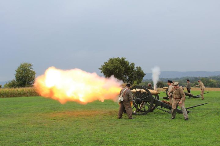 |
| Artillery Demonstration behind New York Monument |
We headed back to the visitor center for a quick break where were privileged to see a group of Confederate reenactors before continuing our morning tour.
 |
| Confederate Reenactors |
We continued to a row of cannons between the visitor center and Mumma Lane, the battery is the position held by the Rhode Island Battery of Captain John Tompkins. This battery provided support for advancing infantry and counter battery fire against Confederate artillery across the valley on the Piper Farm. Tomkins' Battery had 6 guns rather than the 4 represented here. During the 3 hours they held this position they fired 1,050 rounds.
 |
| Union Artillery position (Mumma Road in background) |
Down the rain slickened trail (to the left of the trees in the above picture) we walked, making our way to the Roulette Farm. Two Divisions of the 2nd Corps walked through Roulette's fields on their way to the Sunken (Bloody) Lane. Roulette's House and barn were both used as field hospitals. After the battle, there were 700 soldiers buried in his fields.
 |
| Roulette Farm (house obscured by tree, barn on right) |
 |
| Hills approaching Sunken (Bloody) Lane, The Observation Tower sits at the far end of the lane. |
The Sunken (Bloody) Lane was held by Rodes' Brigade and Anderson's Brigade of D.H.Hill's Division. The nature of the lane being below grade and hills that Union troops had to cover to get to it made for a violent segment of this battle. Union troops were silhouetted against the sky as they crested the hills only about 100 or so yards from the lane. This combined with piecemeal attacks led to high casualty rates for the Union. Eventually the right side of the Confederate line was flanked by Union troops who turned the sunken road into a shooting alley. Confederate losses were approximately 2,500 men (including the mortally wounded General George Anderson), Union losses were about 3,00 (including the mortally wounded General Israel Richardson)
 |
| Mortuary Cannon showing location of the mortal wounding of Major General Israel Richardson Picture taken Spring 2009 |
 |
| Bloody Lane (our approach was from the left) Picture taken Spring 2009 |
From here we took a one hour break for lunch. We were to meet up at Rohrbach Campground on the south side of Sharpsburg. The directions we received were simple enough, drive on Md 65, cross Main Street to Church Street, continue about a mile (just after you cross Antietam Creek) you will see the campground on the left. Great...except it was "Sharpsburg Heritage Days". Main Street was closed for multiple street vendors, and there was a detour that I could have walked through faster than the drive was. I wish I had known about the festivities, I would have planned my day better to at least have checked them out. As it was, I choked down a sandwich that had been in my cooler all morning and chugged a couple bottles of water to chase it while sitting in traffic. I made it to the campground with about ten minutes to spare.
We left the campground parking area and negotiated a Boy Scout encampment...that brought back fond memories watching them sitting around a campfire. There is always the one kid who likes to sit in the smoke. (that was usually me, but I grew up to become a firefighter)
We walked along the Union Advance Trail where Burnside's 9th Corps advance towards Antietam Creek and the Rohrbach (now Burnside's) Bridge. We passed by the quarry on the east side of the creek where rocks were quarried for the building of the bridge. The hillside was extremely steep on the direct approach to the bridge. This was the area that Crook's Brigade and the 11th Connecticut made their initial attack. Nagle's Brigade made the second movement on the bridge (but failed in their attempt). Finally Ferraro's Brigade (notably the 51st Pa and the 51st New York) took the bridge following the promise of whiskey. The 9th Corps suffered 500 casualties in their attempts to secure the bridge, to 160 suffered by Confederate forces. There is a tree at the base of the bridge on the eastern side of the creek that is a known witness tree. It is present in a famous picture taken by Alexander Gardner just 4 days after the battle. Believe it or not, the bridge was open to vehicular traffic until 1966.
 |
| Burnside Bridge from east of Antietam Creek Witness tree on left behind wall |
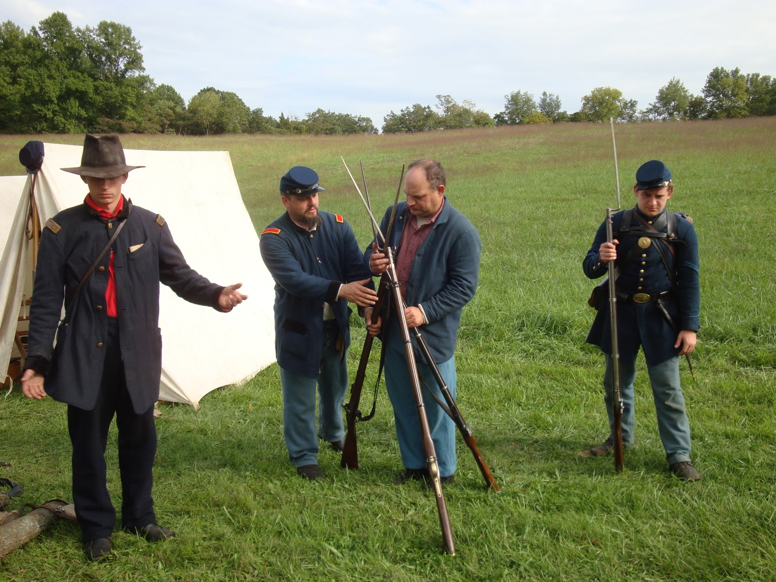 |
| Unstacking rifles for manual of arms demonstration |
We continued along hillsides and trails...
 |
| Final attack trail to 16th Connecticut Memorial |
finally stopping at the 16th Connecticut Memorial. We reviewed the battle at this point when A.P.Hill's Corps arrived from Harper's Ferry to turn the left flank of the 9th Corps line. There the 4th Rhode Island, the 16th Connecticut (who had loaded their rifles for the first time the night before the battle), the 8th Connecticut were driven back from left to right along the left flank of the 9th Corps. I don't know the exact number of casualties suffered but the Rangers said it was 4-5x the number suffered at the Burnside Bridge, so 2000-2500 sounds about right.
Along the way we were able to see the Union artillery position on a ridge line about 1/2 mile away from our position. 24 guns were positioned there and played prominently in the day's battle.
 |
| Clear ridge on right side of picture is site of Union Artillery Position |
An interesting side note regarding this part of the battle. The five Confederate Generals who played a significant part in this battle did not survive the war. Brigadier General Lawrence Branch was killed about 200 yards in front of the 16th Connecticut Memorial. Brigadier General Maxcy Gregg was killed along Jackson's line at Fredericksburg in December of 1862. Brigadier General David R. Jones died of a heart attack in January of 1863. Brigadier General James Archer was taken prisoner at Gettysburg and after being exchanged died of ill health outside of Petersburg in October 1864. Major General A.P. Hill was killed outside of Petersburg Virginia a week before the war ended.
 |
| 16th Connecticut Memorial |
Thus ended the 2 part all day battlefield hike. A member of our group had a pedometer with him, we had hiked as a group about 8 miles. My feet, ankles and knees felt every bit of it too. I wouldn't trade the experience for a million dollars and plan to repeat it next September.
My day wasn't done though...
There was a twilight tour of the National Cemetery given by Rev. John Schildt. He was a fascinating individual. Besides being an author, he served in the US Army on D-Day and was part of the assault on Normandy. A true hero in my book.
I got there a little early and had the opportunity to take a couple pictures of "Old Simon" the monument to the private soldier that is the focal point of the cemetery.
 |
| "Old Simon" The inscription reads, "Not for themselves, but for their country." |
We started the tour with information on the cemetery itself, the design, the history etc. Then we went to see significant parts of the cemetery. There are 4776 Union soldiers buried here of those 1835 are known but to God. There are 200 + soldiers from wars through the Korean War buried here. The cemetery was officially closed to new burials in 1953.
 |
| Unknown Soldier Grave |
Until 1902 unknown soldier's graves were marked with a stone like the one above. The first number is the plot number for the cemetery, the lower number is how many soldiers occupy that grave.
We paid respects to 4 unknown soldiers of the Irish Brigade who's remains were found on the battlefield in 1988. Earlier this year at the Pry House I was able to see artifacts recovered from their battlefield graves that were used to at least identify their regiments. It is believed that the soldier in grave number 4 is possibly Private James Gallagher, Company C, 63rd New York Infantry.
 |
| Memorial to 4 Irish Brigade soldiers, known but to God. |


 |
| These are all from the graves of the 4 unidentified members of the Irish Brigade They were used to help identify the regiment in which they served. |
We heard the story of Sergeant George Simpson, he was the color bearer for the 125th Pennsylvania when he was killed near the Dunkard Church. He is the soldier represented on the unit monument to the 125th Pa.
 |
| Grave of Sgt. George A. Simpson 125th Pa |
 |
| 125th Pa Monument, Sgt George A. Simpson represented on top monument |
We learned about Captain Werner Von Bachelle. He was the commander of Company F, 6th Wisconsin. He was killed near the cornfield along the Hagerstown Pike. He had a Newfoundland that he had taught to do military salutes and such. After the battle, the lifeless dog was found laying across Von Bachelle's body. They were buried together on the battlefield, and it is believed they are still buried together in the National Cemetery.
 |
| Grave of Capt. Werner Von Bachelle, Company F, 6th Wisconsin The Iron Brigade |
An exception made regarding the closure of the cemetery for new burials for a Keedysville (about 3 miles from Antietam) sailor Fireman Patrick Howard Roy who was killed in the attack on the USS Cole.
 |
| Grave of Fireman Patrick Howard Roy. |
We also saw the grave of General Jacob Duryee (of Duryee's Zouaves fame). We were told how the Lodge Building was the original visitor center for the battlefield. And we were told about the VIPs who had given Memorial Day addresses at the cemetery. Rev. Schildt told us about the one year when aircraft from a local Air National Guard base had dropped flowers on the cemetery during a flyover. That was something I wish I could have seen. We were told that it is believed that in the days leading towards the battle, it is believed that General Lee used the land in the cemetery to have an overview of the area to help him decide how and where to place his troops.
We ended our tour of the cemetery looking out the back towards the Hawkin's Zouaves Monument.
 |
| Hawkin's Zouaves Monument in background looking out from National Cemetery. |
I called it a day around 19:30 and started driving home to Pittsburgh. It was a long day, that I wouldn't trade for anything.
As always feel free to comment.
No comments:
Post a Comment